
Once again, Langkawi will be the center of attraction by hosting the forth biennial International UNESCO Conference on Geoparks 2010 from 11-16 April 2010 (which is today).
Surprisingly, the venue for the conference will be at Awana Porto Malai Langkawi. And interestingly, this is what M and I found out not too long ago at Pulau Ular.
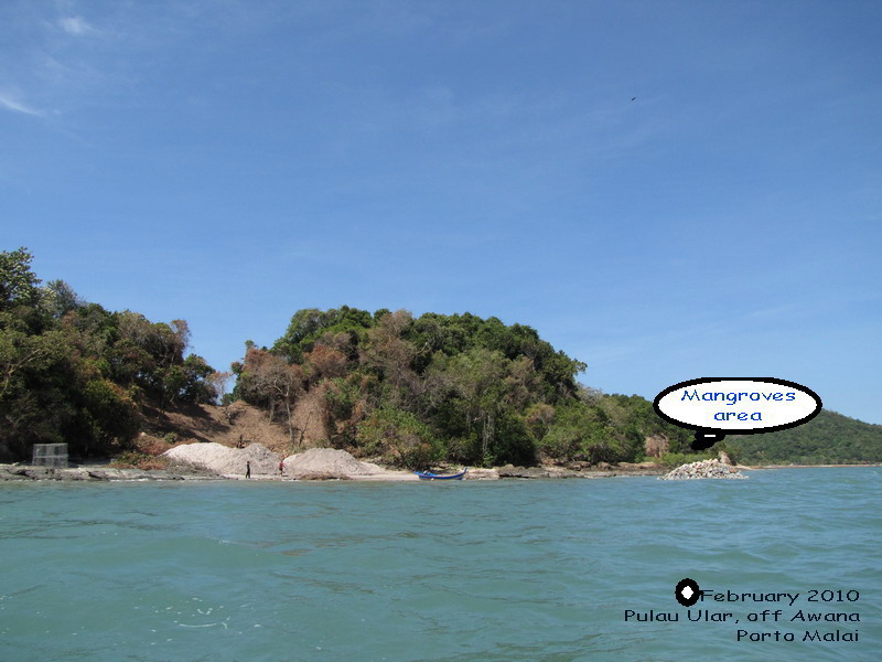
Location: Pulau Ular (Ular Island)


When you stand at the jetty or even before the entrance of Awana Porto Malai, the work site or dump site cannot be seen at all. These cheeky people.
Geological Interest on Pulau Ular:
Pulau Ular is a geological monument that forms part of Langkawi's Geopark site in the Southern region which is the Dayang Bunting Marble Geoforest Park. It is a small island and its present shapes and morphologies were formed due to selective erosion by wave since thousand of years ago. The island is made up of several undulating hills separated by abrasion platforms, producing its unique snake-like appearance if viewed from the east to southeast. These hills, together with five sets of elevated ancient abrasion platforms at approximately +5m, +4m, +3m, +2m and +1.5m above the present low tide level, have produced a spectacular geological landscape. The uniqueness of Pulau Ular is the pebbly mudstone suggests to be of marine glacial deposits (diamictite).
Please scroll to the bottom to find out what Dropstones are.
What Awana Porto Malai has done to Pulau Ular not too long ago?


Do you think the local authorities knew about this? Or they closed one eye?
Once again, this is the same old story on how our local government agencies are allowing irresponsible operators building and developing yet they allowed the degrading of Langkawi Geopark status and standard.
M has written a letter to LADA (LAngkawi Development Authority) to highlight on this and yet any action taken??
Dropstones
Dropstones are isolated fragments of rock found within finer-grained water deposited sedimentary rocks. They are in various sizes from small pebbles to boulders. The critical distinguishing feature is that there is evidence that they were not transported by normal water currents, but rather dropped in vertically through the water column.
Glacial dropstones, involving rocks falling out of icebergs, are one of the most common types of dropstone preserved in the geological record, particularly when deposited in low-energy deep sea or lake environments. As glaciers move across a surface, they pluck rocks from it, and incorporate them into their mass. At the coast, fragments of glacier detach and float away as icebergs, which are often transported many miles into the ocean, where they melt and deposit their load. When entrained rocks sink to the ocean floor, they can be incorporated into the oceanic sediments, which are typically fine grained.
References:
1) Field Guide to Geology of Langkawi Geopark by Che Aziz Ali, Kamal Roslan Mohamed, Mohd Shafeea Leman, Ibrahim Komoo and Tanot Unjah.
Please scroll to the bottom to find out what Dropstones are.
What Awana Porto Malai has done to Pulau Ular not too long ago?

This barge was spotted carrying a tractor and tonnes of rocks, debris.

Barge was moving towards Pulau Ular

Barge was suspected dumping debris and rocks onto Pulau Ular
Do you notice the wired cage on the left? We suspect that they are constructing some sort of wave breakers by putting the rocks into the wired cage.

When you stand at the jetty or even before the entrance of Awana Porto Malai, the work site or dump site cannot be seen at all. These cheeky people.

A poorly maintained information board.

I think this must have been replaced by now. I had noticed the local authorities were placing new information boards within these two weeks especially in the three Geoforest Parks which are in Kilim, Mat Cincang and Dayang Bunting. The only reason why they had no choice to replace new ones is to save their embarrassment. The delegates will visit these parks during the conference period. After the conference, they will ignore the maintenance and conveniently forgetting the existence of facilities.

This is one of the new information board that they put up recently. This board picture was taken at Temurun Waterfall.
Do you think the local authorities knew about this? Or they closed one eye?
Once again, this is the same old story on how our local government agencies are allowing irresponsible operators building and developing yet they allowed the degrading of Langkawi Geopark status and standard.
M has written a letter to LADA (LAngkawi Development Authority) to highlight on this and yet any action taken??
Dropstones
Dropstones are isolated fragments of rock found within finer-grained water deposited sedimentary rocks. They are in various sizes from small pebbles to boulders. The critical distinguishing feature is that there is evidence that they were not transported by normal water currents, but rather dropped in vertically through the water column.
Glacial dropstones, involving rocks falling out of icebergs, are one of the most common types of dropstone preserved in the geological record, particularly when deposited in low-energy deep sea or lake environments. As glaciers move across a surface, they pluck rocks from it, and incorporate them into their mass. At the coast, fragments of glacier detach and float away as icebergs, which are often transported many miles into the ocean, where they melt and deposit their load. When entrained rocks sink to the ocean floor, they can be incorporated into the oceanic sediments, which are typically fine grained.
References:
1) Field Guide to Geology of Langkawi Geopark by Che Aziz Ali, Kamal Roslan Mohamed, Mohd Shafeea Leman, Ibrahim Komoo and Tanot Unjah.


Hi, interesting observation. If the steel cages are on Pulau Ular, they must be constructing gabions on the island. For what purpose, I dont know. Sometimes gabions are used as temporary structures before something permanent is built. May be they are planning to build a jetty or something on Pulau Ular. Just guessing.
ReplyDeleteHey, I saw all the new signage at Kilim and Bat Cave in the last few weeks but didn't connect it to the Geopark conference. Thanks for pointing that out. Am sure the conditions of these new boards will be left to deteriorate and rot and they will become an eyesore soon enough!
ReplyDeleteHi YM Monyet King;
ReplyDeleteYes, you may be right there. Gabions? I learnt a new word for that wired cage.
Pulau Ular does not interest awana porto malai. We felt that they were using P.Ular as the work site and the gabions would be placed at Awana porto malai itself.
Hi Mandy;
I had updated this blog by putting the latest signage picture. This new one is nice indeed. Let's guess how long it will last before graffiti takes place.
I have group check-in Awana n my guest have a free trip to SANTAI at Pulau Ular beach.. Free transfer by Awana.
ReplyDeleteHi Anonymous Oct29th;
ReplyDeletePlease take note that the island is known to have lots of dangerous and venomous snakes. So, you better tell your guests not to SANTAI there so much. You don't want any unwanted incidents to happen.